
UAV-Based Spectral Analysis Reveals Flood-Induced Sediment Transport Patterns
The Challenge: When rivers flood, their destructive power is shaped by more than just water volume—the composition of sand, gravel, and silt in the riverbed determines how and where erosion occurs, and which infrastructure faces the greatest risk. Traditional soil sampling methods are too slow and spatially limited to capture the full picture of sediment distribution after major floods, leaving engineers unable to predict future flood behavior or assess infrastructure vulnerability.
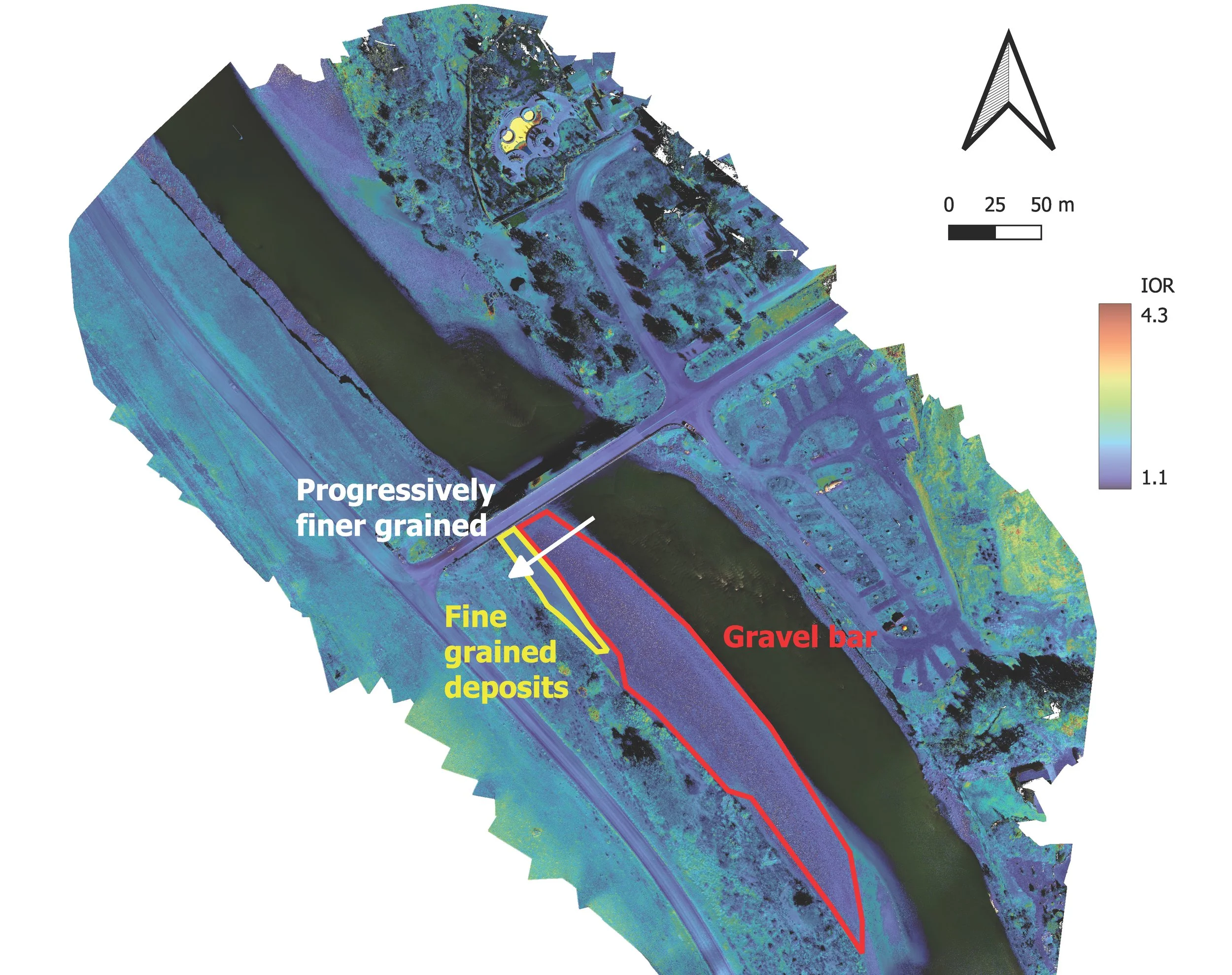
A processed multispectral image from the Cinnabar Bridge on the Yellowstone River. Image credit: Michael Gardner.
A New Approach: A research team led by Michael H. Gardner of UC Davis, supported by the National Science Foundation, developed an innovative solution using uncrewed aerial vehicles (UAVs) equipped with advanced multispectral sensors. To validate their approach in real disaster zones, they partnered with the RAPID Facility, which provided critical instrumentation and field support for post-disaster reconnaissance missions following the 2021 Western European floods in Germany's Ahr Valley and the 2022 Yellowstone River flooding in Montana.
Data & Discovery: The team's breakthrough came through the "Iron Oxide Ratio" (IOR)—a technique that analyzes reflected red and blue light signatures captured by RAPID's multispectral sensors to distinguish fine-grained silts from coarse sands and gravels across entire flood zones. This method leverages the higher iron oxide content in clay minerals compared to sandy soils, creating distinct spectral signatures visible to the sensors. At the Yellowstone River's Cinnabar Bridge, their analysis revealed that a large, erosion-resistant gravel bar upstream had channeled floodwaters directly into the northern bridge abutment, explaining the concentrated damage pattern. Similar analysis in Germany's Ahr Valley successfully mapped the spatial distribution of flood deposits, revealing sediment transport patterns invisible to conventional assessment methods.
Impact: This research, published in the Journal of Flood Risk Management, provides engineers and scientists with a transformative new capability for rapid, landscape-scale assessment of flood-affected river systems. The UAV-based methodology enables comprehensive mapping of sediment classes within hours rather than weeks, revealing critical information about flow patterns and erosion potential that was previously impossible to obtain at such scale and speed. By identifying which channel sections contain erosion-resistant materials versus vulnerable fine sediments, engineers can now predict where future floods are likely to cause the most damage and design infrastructure accordingly. The RAPID Facility's provision of cutting-edge multispectral sensors and field expertise was essential to proving this concept in real disaster environments, contributing to a future where flood risk assessment can be both faster and more comprehensive.
Citation: Gardner, M. H., Stark, N., Ostfeld, K., Brilli, N., & Lemnitzer, A. (2025). Uncrewed Aerial Vehicle-Based Multispectral Imagery for River Soil Monitoring. Journal of Flood Risk Management, 18, e70027. https://doi.org/10.1111/jfr3.70027