
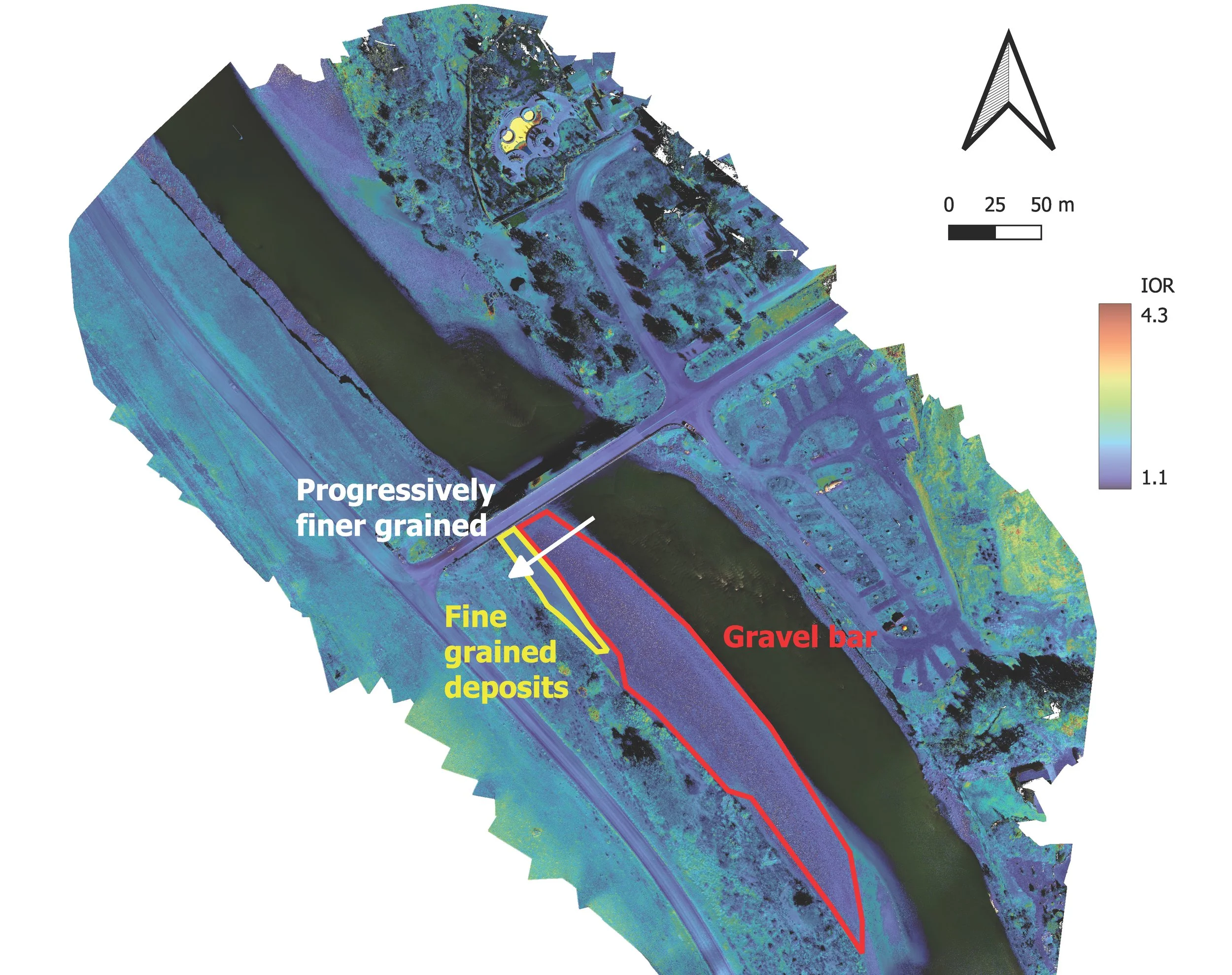
UAV-Based Spectral Analysis Reveals Flood-Induced Sediment Transport Patterns
When rivers flood, their destructive power is shaped by more than just water volume—the composition of sand, gravel, and silt in the riverbed determines how and where erosion occurs, and which infrastructure faces the greatest risk. Traditional soil sampling methods are too slow and spatially limited to capture the full picture of sediment distribution after major floods, leaving engineers unable to predict future flood behavior or assess infrastructure vulnerability.

How RAPID Technology Revealed Pandemic Behaviors
During the COVID-19 pandemic, public health officials issued critical social distancing guidelines to slow virus transmission. However, understanding how the public actually adhered to these recommendations over an extended period across an entire metropolitan area presented a major challenge for social and health scientists. Existing methods like stationary CCTV footage provided only limited spatial coverage and momentary snapshots, while mobile phone data suffered from known representation biases, leaving researchers without comprehensive tools to study real-world interpersonal distancing behaviors at scale

Quantifying Disaster Debris Faster with Remote Sensing
After a major disaster like a hurricane, the sheer volume of debris can be overwhelming, choking roads, slowing recovery, and costing billions to manage. For emergency managers, planning an effective cleanup operation depends on one critical question: How much debris is there? Existing prediction models are often inaccurate, and getting real-world data is difficult, leaving communities struggling to allocate the right number of trucks, personnel, and disposal sites.

Seeing the Invisible: RAPID Technology Reveals Ephemeral Floodwater Marks
High-water marks are among the most critical, yet perishable, types of data following a flood. They reveal the disaster's true depth and extent, informing future flood risk assessments and mitigation strategies. However, these vital indicators can fade rapidly due to drying, environmental exposure, and cleanup efforts, often becoming invisible to the naked eye within weeks. When reconnaissance teams cannot safely access disaster zones immediately after flooding, this essential information is frequently lost forever, hampering efforts to understand flood behavior and protect communities.
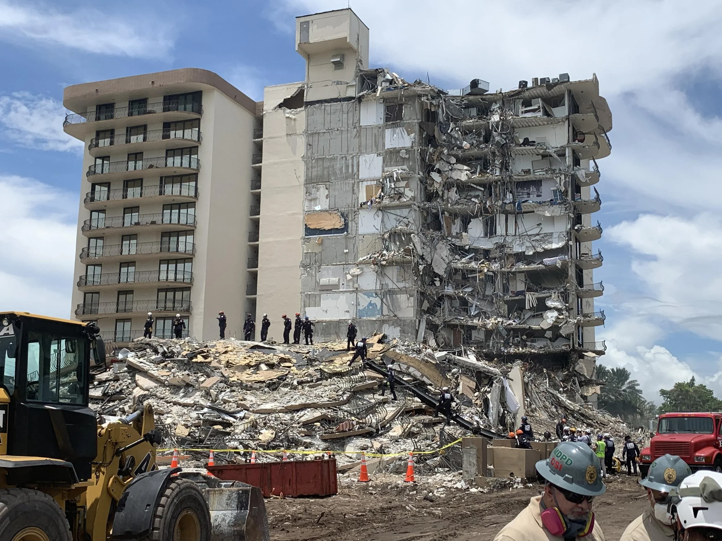
Investigating the Champlain Towers Collapse
In the early morning hours of June 24, 2021, the 12-story Champlain Towers South condominium in Surfside, Florida, suddenly collapsed, killing nearly 100 people in what became one of the deadliest engineering failures in U.S. history. With no obvious cause for the abrupt structural failure, the National Institute of Standards and Technology (NIST) was tasked with leading the complex federal investigation to answer the urgent question: Why did it happen?

How Advanced Reconnaissance Answered the Question of the Haines Landslide
In December 2020, an unprecedented "atmospheric river" event triggered a devastating landslide in Haines, Alaska, destroying homes and killing two residents in an area thought to be safe. The urgent question for the community and for scientists was: Why did the landslide happen here, and could it have been foreseen?

A Community's Lifeline: Protecting Schools and Hospitals from Wildfire
In November 2018, the Camp Fire became the most destructive wildfire in California's history, devastating the town of Paradise. The fire destroyed over 11,000 homes, but its impact on the community's critical lifelines—its schools and only hospital—was just as profound, crippling the town's ability to care for its residents and begin recovery. Understanding exactly how these essential buildings failed was crucial for learning how to protect other at-risk communities in the Wildland-Urban Interface (WUI).